
Real-Time Simultaneous Localisation and Map Generation for Autonomous Navigation
Real-Time Simultaneous Localisation and Map Generation for Autonomous Navigation
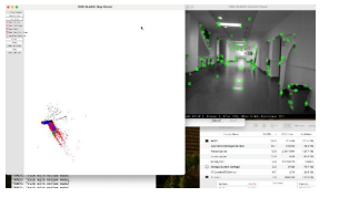
Abstract: GPS coverage issues, as well as spoofing, can significantly affect the navigation of autonomous vehicles. The current state-of-the-art relies on visual SLAM (Simultaneous Localisation and Map generation) for localisation, as in the recent Lockheed Martin’s NorthstarTM system, reaching resolution down to centimetres. SLAM relies on estimating location based on analysing the motion (visual odometry and inertial) and computing the relative position and pose (orientation) of the camera, thus constructing a local map. The map is continuously extended during motion and is eventually used (when visiting a previously visited position) to decrease drift. Also, SLAM systems allow for real-time processing capabilities, and there are high-quality open-source implementations of which. However, SLAM has limitations, which include low accuracy in low-texture areas, in addition to the high computation demand stressing the capabilities of embedded processors in vehicles. The objective of this proposal is to provide a prototype of the state-of-the-art localising camera in an unknown environment with no GPS and conduct an analysis of the technology, identifying limitations for the problem at hand and identifying enhancements for later phases of the project.
